
If you’ve been following the discussion about South Main Street (the section between Wickendon/Point Streets and College/Westminster Streets) you’ll know that South Main would be greatly improved for drivers, bicyclists, pedestrians, and transit users if it got a make-over. So I’m very happy to announce that the Rhode Island Bicycle Coalition has drafted a letter to the heads of RIDOT and the I-195 Project to point out the shortcomings in the current plan, saying (full letter) that “We believe that as proposed, these plans do little to increase access to all users; moreover, the decision to start this work at James Street even as the I-195 Commission has issued specific developer criteria for that stretch of road and riverfront is unfortunate in the extreme. It demonstrates yet again a failure to implement both the city’s and the state’s goals for complete streets and integrated transportation into the actual operations of their agencies.”
I’d like to go over a few of RIDOT’s responses at the bike & ped meeting and explain why they don’t make sense.
Here are their objections:
1. South Main Street doesn’t have enough pedestrians to remove “beg buttons” from intersections like Waterman & Main. According to current counts, this intersection has 90-160 pedestrians per hour each day. That means that in the sixteen hour life of a fully awake city like Providence, Waterman & Main 1400-2500 individuals crossing it. That’s quite a lot of people. South Main Street, of course, has other crossings which have their own pedestrian counts, and so taken together, there are lots of people going across this street all the time. The Waterman & Main intersection, which was particularly highlighted at the bike & ped meeting, is site of the RIPTA trolley tunnel and is within a half mile of the Thayer and Wickenden shopping districts, and just as close to downtown, Brown, URI, and JWU. And the RISD campus is, of course, right there.

2. We need to move as many cars as possible.
It just happens that moving cars efficiently is what slower streets do. It’s counterintuitive, but think of it as the Tortoise and the Hare Effect. What makes lots of signals necessary on streets is not just the number of vehicles present, but also how fast they are going. In Providence, we see a lot of streets that are nominally 25 mph where drivers are pushing closer to 35 or 40, but are getting stopped at lights. That red light time is eating up all of the advantages of going fast. A number of cities have not only narrowed the lanes of two lane roads like South Main to improve efficiency, but have even taken roads down from two lanes to four and narrowed lanes. By adding more self-regulating junctures, these streets have improved travel times.
Look at the explanation video by the head of the Washington State DOT (the synth music is amazing). Keep in mind, these efficiencies come without any change in the mode of transportation people use. Which brings us to. . .
3. There are 20,000 vehicles a day!
RIDOT discounts the mode share changes that happen to a street when road diets are accompanied by new options for transportation. For instance, just by changing the intersection at Waterman & Main to one with a four-way crosswalk instead of an annoying L-shaped one, a lot more people will choose to walk there (as a native Philadelphian, I find New England’s L-shaped crosswalks to be a particular affront, because I don’t even think I’ve seen such a ridiculous thing in the suburbs, let alone in a city that prides itself as being in the top-ten of walkable cities. Pedestrians always have the right of way at a crossing, so the crosswalks should reflect that). Adding protected bike lanes has been shown to bring bike traffic above the level of car traffic almost instantly, such as in Chicago‘s Kinzie Street. And traffic congestion is not a linear phenomenon, so even more modest changes to traffic patterns can completely eliminate traffic jams for drivers. Just by happenstance, Portland’s Hawthorne Bridge, where lanes once led into a freeway, they now are protected bike lanes across the bridge and into a bike path. The bridge carries 27,000 vehicles a day, but more than 5,000 of those are bikes. Streetsblog writes that without the bike lanes, car traffic would have had to become more congested to meet travel demand.
Unfortunately, RIDOT say. . .
4. There’s double parking, so we need a second lane!
This is an interesting argument, because RIDOT told us in regards to the L-shaped crosswalks that it simply “won’t put a crosswalk where it’s not safe”. It’s apparently very concerned with making sure we follow the rules. But where double parking is concerned, apparently this is not the case. Although illegal, RIDOT argues that we should add 12′ of vehicle road space to the street to meet an unauthorized activity, even though upkeep on such a road space would be additional money for the state or city, while ticketing double-parked trucks would be revenue neutral or revenue gaining.
And the argument made by RIDOT is that double parking would have to happen on a single lane street, because there’s just not enough parking, but with the simple addition of parking meters set to create an 85% occupancy of spots (matchbox cars!), drivers and trucks can always have a space available on every block to make sure that things can get in and out (as I’ve mentioned, they already pay for this in their taxes, they just don’t get the efficiency in return).
5. Twelve feet is just a standard lane width.
Well, it depends on where you are. If you’re in Vancouver, British Columbia, the only large city in North America with no freeways at all, then it’s standard to have a maximum lane width of 3 meters, or 9′ 10″. It’s a funny thing, Vancouver has grown its economy and its population and has had a reduction in traffic congestion during the same period. Oh, and it’s Canada, so they can afford things like universal healthcare because they don’t waste all their money on beg buttons and high-volume, high-speed roads.
6. What about emergencies?
Well, as I’ve pointed out, experts on streets like Jarrett Walker and David Hembrow have good answers to these questions. Transit or bike lanes can be used quickly in emergencies for fire trucks or ambulances, while streets full of cars will back those vehicles up. Hembrow in particular shocked me with the astounding gap between the amount of fire fighting infrastructure we have to invest in compared to the Netherlands in order to deal with our poor response times. So even if none of the other benefits of a new street design materialized, this would be a worthwhile reason.
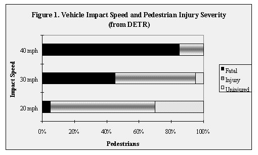
7. The street really isn’t that fast.
Many drivers (and apparently RIDOT) have the impression that one has to be going at full highway speed to be going to fast for a neighborhood. But this infographic shows that pedestrian safety quickly changes from 20 mph to 40 mph.

While drivers on South Main may only approach 35 or 40 mph, and have to stop in between at lights, this does not make for a safe and comfortable street for everyone.
8. It’s just paint.
This is the most interesting one, because it really reveals their thinking. The “it’s just paint” argument says that it only costs a few thousand dollars to do much of what they’re doing, and it will soon wash away, so why not just wait and change the street if the bikers and pedestrians show up? The problem is this gets the process completely backwards. Pedestrians and cyclists show up because an area feels good to walk or bike in. By the same token, places where streets have been narrowed (or even full highways removed–such as Milwaukee, Portland Oregon, San Francisco, and New York) have seen drops in traffic congestion without that congestion going elsewhere because people are surprisingly resilient and able to self-manage their own travel when given options. The most proximate example of a neighborhood that would have gotten a highway and never did is Jamaica Plain in Boston, which today instead has a train and multi-use path instead of I-95 running through it.