 Over the past several years, right-wing news talkers have made a winter ritual out of ridiculing global warming whenever there’s a big snow event in the mid-Atlantic or a major cold wave that reaches the South.
“Global warming…? It’s freezing!” they spew.
Except this kind of winter weather is, in fact, a result of global warming. What’s worse is that it’s going to be like this for a long, long time.
Global Warming, Climate Change and Weather
The best way to make yourself look like an ignoramus on this topic is to equate surface air temperatures with global warming. If it’s hot in the summer, it’s not necessarily global warming that’s making it hot. Summer is hot, right?
You have to ask, “Why is it hot? Is it that much hotter?” It may be that global warming is making it hotter than ever, or it could just be a hot summer.
Air gets hot; air get cold. Water, on the other hand, gets less hot and less cold. Water is a far more stable repository of heat than air. That’s why it’s cooler at the shore in the summer when it’s hot in the city. And warmer at the shore in the winter when it’s cold inland. Water temperature resists the day-to-day vagaries of air temperature.
And, mostly, air moves around a lot. Water moves, but much more slowly than the air, so it’s more stable in that regard as well. Unless it’s moving as vapor in the air.
Climate is the basic conditions—the raw materials of air, water vapor, land masses and, of course, that big old sun. Weather is what happens when these conditions interact on a day-to-day basis.
Evaporating oceans that become water vapor, ride in air over a land mass and then fall in the form of rain or snow is what makes life on this planet possible. If this were to stop, we would all die. Fast. But it needs to happen within a certain range and within a certain seasonal pattern for the ecosystem to work is such a way that our lives are possible.
Global warming has deposited exceptional amounts of heat in the oceans, making them more evaporative. This increased amount of available water vapor has changed the climate in ways that we are still trying to understand. What we know for sure is that the exceptional weather results we see these days are unlike anything in our recorded history, and in some cases they are unlike anything at any time that science has been able to study through fossils or ice core samples.
North America’s January Started in Siberia…in October

Dr. Judah Cohen is no hippie. He works for one of the world’s leading private weather prediction services. He gets paid quite handsomely to help companies anticipate weather months in advance and put risk mitigation strategies in place.
As I’ve written here repeatedly, major insurers are the leading climate alarmists. Exceptional weather events destroy property, and they’re the ones who have to pay.
Over the past 15 or so years, the northeast US has seen a substantial increase in major winter snow events—costly to cities and states—that did not correlate with an exceptional Labrador counter-current, a coastal down flow of Arctic waters generally associated with a snowy northeast winter. And the storms would sometimes track far south of the traditional path.
Dr. Cohen searched the climate data from around the globe and found something that correlated well: October snow in Siberia. Like the new winter weather in the northeast, these Siberian snows were also new. Typically, these areas of western Siberia remained barren rock through the autumn and into the winter. Suddenly, these remote areas began receiving significant amounts of snow in the month of October.
This change in Siberia in October affects our weather in January and February. Or so Dr. Cohen’s team—and all the companies that pay them so much money—believe.
When this area in Siberia gets covered in a smooth sheet of white snow, it radiates substantially more solar heat than the darker, rumbled rock formations did. This mass of rising warmer air becomes so powerful that it pushes the giant dome of frigid air that covers the polar region in the winter down over North America.
Interlude: Polar Ice
Before addressing the madness that is the polar vortex, we should ask the question, “Why is it now snowing in Siberia in October?”
The answer is simple: because it can.
Rain or snow requires the right combination of temperature gradient (hot and cold temperatures near each other) and available moisture (water vapor). The North Pole is cold pretty much all the time; Siberia gets warm in the summer. So the temperature gradient has always been there.
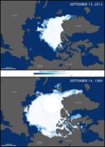
What’s new is the available moisture, in the form of increasingly greater summer melt of the northern polar ice cap. The illustration (click for bigger view and attribution) compares the peak melt in mid-September of 1984 and 2012. Clearly, substantial amounts of new, open water can feed the prevailing westerly winds (moving roughly top to lower left) with moisture that then falls as snow in Siberia (left and lower left). That’s basic meteorology: more or warmer water means more precipitation.
Polar Vortex, Go Home. You’re Cold
The Siberian snowpack creates rising air that reaches the polar air mass and pushes it off its natural polar resting place so it more-or-less spills itself over North America.
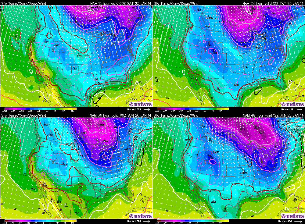
The polar vortex is a weak, low pressure system that rotates counterclockwise. This 72-hour forecast loop shows the effect clearly. [NOTE: Link will open in a separate tab. Also, this link is time dependent, so if you’re not looking at this on or about January 25, 2014, it may not show what’s described.] As it spins, it polar air plunges down the western flank well into the South. For the first time ever, people in Louisiana are seeing their pipes burst because the construction of their houses does not account for this kind of weather.
Perversely, when the polar vortex descends over North America, it can sometimes be colder at the bottom of Hudson Bay than it is on the North Pole. Note how warmer air presses up over the northeast side of the system in the forecast loop.
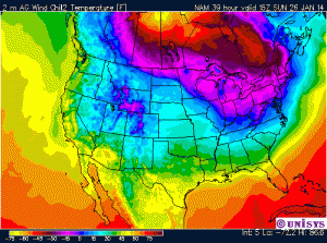
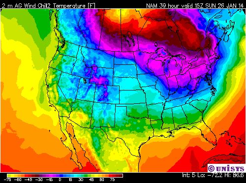
One thing the polar vortex can’t do is be stronger than the ocean. So it gets stuck in the triangle created by Siberia that is pushing it away and the warm waters of the Gulf of Mexico and the Atlantic. The illustration at right shows the 39 hour wind chill forecast: 15Z SUN 26 JAN 14 (about 10am local time on Sunday, January 26).
Looks like about -10 F in Little Rhody. So, yeah, polar vortex. Cold, horrible and anomalous. Also, not going anywhere.
Have a great Sunday!


 Sally Gabb, a member of the Chapel’s Worship Committee, reflects on the “primary metaphor” within human culture – weather.